Chief Minister Himanta Biswa Sarma released the report on the status of tigers in the Kaziranga Tiger Reserve (KTR), online to mark Global Tiger Day on 29 July.
UPSC CSE Relevance:
UPSC CSE in prelims examination has focused on Species in news every year UPSC asked at least one question related to species. A case in point is a following PYQ.
UPSC CSE PYQ 2019:
Q: Consider the following statements: 1.Some species of turtles are herbivores. 2.Some species of fish are herbivores. 3.Some species of marine mammals are herbivores. 4.Some species of snakes are viviparous. Which of the statements given above are correct? A) 1 and 3 only B) 2, 3 and 4 only C) 2 and 4 only D) 1, 2, 3 and 4
The Report:
Assam’s Kaziranga Tiger Reserve (KTR) has recorded the third-highest tiger density in India.
Bandipur Tiger Reserve – Karnataka – highest density
Jim Corbett National Park- Uttarakhand
Kaziranga Tiger Reserve- Assam
Officials said key factors behind the population increase included habitat expansion and protection.
Note: Orang(Area:492.46) is the smallest tiger reserve not Bor(Area: 816.27)
NOTE : The highest population of Tigers is found in Jim Corbett. While the highest density of tigers per unit area is in Bandipur Tiger Reserve.
Tiger Reserves:
Notified by State Govt. on the advice of the National Tiger Conservation Authority (NTCA).
58 Tiger Reserves declared so far.
The State govt. can not change the boundary or denotify the Reserve except on the recommendation of NTCA.
A Tiger Reserve can be denotified only in public interest.
Largest Tiger Reserve – Nagrajunasagar Srisailam TR in Andhra Pradesh
Smallest Tiger Reserve – Orang TR in Assam
Tiger Reserve with Maximum Tigers – Jim Corbett
Highest Density of Tiger – Bandipur TR
Kaziranga National Park or Tiger Reserve:
Kaziranga National Park, located in Assam, is renowned for its conservation of the great one-horned rhinoceros and rich biodiversity.
Contains about two-thirds of the world’s great one-horned rhinoceros population—over 2,400 individuals as of recent counts.
Designated as a UNESCO World Heritage Site in 1985 due to its unique natural environment and successful wildlife conservation.
Declared a tiger reserve in 2006 and has one of the highest densities of tigers in the world, alongside elephants, wild water buffalo, and swamp deer.
Established as a reserve forest in 1905 and became a national park officially in 1974; it has expanded from its original area of 232 sq km to about 430 sq km.
The terrain includes marshes, tall elephant grass, tropical forests, and riverine habitats formed by major rivers like the Brahmaputra.
Recognized as an Important Bird Area, hosting migratory birdslike lesser white-fronted goose, ferruginous duck, and various stork species.
Home to 35+ mammal species, including endangered and threatened species like Bengal tigers, elephants, leopards, and eastern swamp deer.
Seven Major Cats:
Cat
Scientific Name
Max Weight
Range
Habitat
Coat & Appearance
Unique Features
IUCN Status
Tiger
Panthera tigris
300Kg
Asia
Forests, grassland
Orange with black stripes
Largest cat, strong swimmer, solitary
Endangered
Lion
Panthera leo
250 Kg
Africa, small pop. India
Savanna, grassland
Tawny, males with shaggy manes
Only truly social big cat, iconic roar
Vulnerable
Jaguar
Panthera onca
150 Kg
Central & South America
Forests, wetlands
Rosetted spots, stocky build
Strongest bite, swims well, hunts caimans
Near Threatened
Leopard
Panthera pardus
90kg
Africa, Asia
Forests, savanna
Rosettes, slender build
Highly adaptable, climbs trees, stashes prey in trees
Vulnerable
Snow Leopard
Panthera uncia
50kg
Central Asia mountains
Alpine, rocky
Smoky-grey, spots/rosettes, long tail
Thick fur for cold, elusive, can’t roar
Vulnerable
Cheetah
Acinonyx jubatus
70kg
Africa, Iran (few remain)
Open plains
Slim, deep-chested, black “tear marks” on face
Fastest land mammal, non-retractable claws
Vulnerable
Cougar (Puma)
Puma concolor
80kg
North & South America
Mountains, forests
Tawny, no spots, long slender body
Largest small cat group, purrs not roars, excellent leaper
Least Concern
Size: Tiger is largest; snow leopard is smallest among these seven.
Range: Africa (lion, leopard, cheetah); Asia (tiger, leopard, snow leopard, cheetah reintroduction); Americas (jaguar, cougar).
Social behavior: Only lions form prides; others are solitary.
Adaptations: Cheetahs are built for speed; jaguars for power; snow leopards for cold/altitude
All of them use scent marking to mark their territories.
Steps for Conservation:
International big cat alliance (IBCA):
The IBCA was launched by the Prime Minister Shri Narendra Modi on 9th April,2023, during the event ‘Commemorating 50 years of Project Tiger’.
IBCA headquarters in India
It was launched with the aim of conservation of seven big cats – Tiger, Lion, Leopard, Snow Leopard, Cheetah, Jaguar and Puma – with membership of all UN countries/the range countries harbouring the said species and non-range countries where historically these species are not found but interested to support big cat conservation.
The IBCA was established by Government of India, through the nodal organisation viz., National Tiger Conservation Authority (NTCA), Ministry of Environment, Forest & Climate Change (MoEFCC).
About TX2:
It was clear that business-as-usual approaches were not working when wild tiger populations did not stop declining despite conservation efforts.
The global tiger population hit an all-time low; there were only around 3,200 left in the wild by 2010.
In light of this critical situation, the governments of all 13 tiger range countries came together for the first time at the St Petersburg Tiger Summit during the same year.
There, they committed to the most ambitious conservation goal ever set for a single species – to double the number of wild tigers by 2022, the next Chinese Year of the Tiger.
Defence Research & Development Organisation (DRDO) conducted two consecutive successful flight-tests of Pralay missile from Dr APJ Abdul Kalam island off the coast of Odisha.
UPSC CSE Relevance:
UPSC CSE in prelims examination has focused on Defence sector in GSIII. A case in point is a following PYQ.
UPSC CSE PYQ 2014:
Q: With reference to Agni-IV Missile, which of the following statements is/are correct? 1. It is a surface-to-surface missile. 2. It is fuelled by liquid propellant only. 3. It can deliver one-tonne nuclear warheads about 7500 km away. Select the correct answer using the code given below. A 1 only B 2 and 3 only C 1 and 3 only D 1, 2 and 3
Important facts about Pralay:
Indigenously-developed
Solid propellant
Quasi-ballistic – will be the first ballistic missile in India’s missile arsenal meant for conventional strikes. [Quasi ballistic – because of its low altitude trajectory and maneuverability unlike conventional ballistic missiles.]
Surface-to-surface missile
Range of 400 Km
Employing state-of-the-art guidance and navigation to ensure high precision.
Capable of carrying multiple types of warheads against various targets.
Developed by Research Centre Imarat in collaboration with other DRDO labs and industry partners – Bharat Dynamics Limited & Bharat Electronics Limited and many other industries and MSMEs.
Pralay adds to the BrahMos and Parahar missiles already in the inventory giving the Indian military an option for standoff missile strikes across the border.
Comparable with China’s Dong Feng-12, Russian 9K720 Iskander, US Army’s Precision Strike Missile (PrSM) and South Korea’s Hyunmoo-2, Pralay is designed to deceive anti-ballistic missile interceptors.
Aspect
Cruise Missiles
Ballistic Missiles
Flight Path
Remain within the Earth’s atmosphere, fly at low altitudes
Arched trajectory: boost, midcourse (may exit atmosphere), and terminal phases.
Propulsion
Powered by jet engines (air-breathing) throughout their flight
Powered by rockets only during initial phase
Maneuverability
Guided and maneuverable throughout flight; high precision.
Guidance only during early (boost) phase; follow ballistic (pre-set) path
Speed
Usually subsonic or supersonic
Fast: supersonic or hypersonic, especially intercontinental missiles
Detectability
Hard to detect (low altitude, can evade radar)
Easier to detect (visible during boost; high radar/infrared cross-section)
Payload
Typically single, smaller warheads
Capable of carrying larger, multiple warheads (including nuclear)
Targeting
Used for tactical, precise strikes on specific targets
Used for strategic, long-range mass destruction; cities, major assets
Examples (India)
BrahMos, Nirbhay
Agni series, Prithvi series, K-series
Practice Question:
Question: Consider the following statements about Pralay Missile
It is air-to-surface missile.
It will be the first ballistic missile in India’s missile arsenal meant for conventional strikes.
It has 4000km range with Solid propellant fuel.
How many of the above statements is/are incorrect?
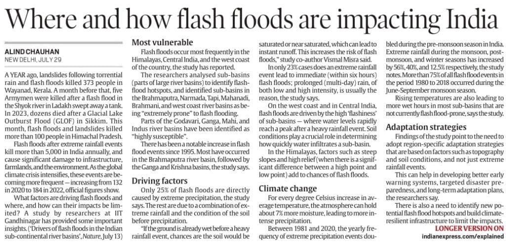
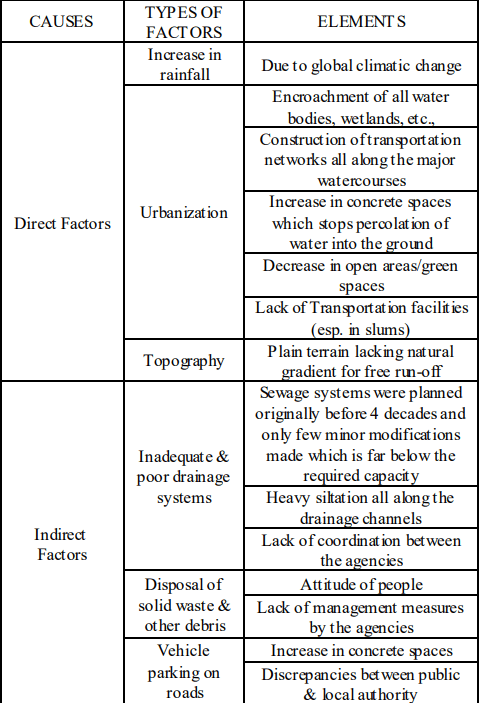
Flash floods have increasingly affected various parts of India in 2024, including Himachal Pradesh, where over 100 people recently died due to landslides and floods. A new study titled “Drivers of flash floods in Indian sub-continental river basins” (IIT Gandhinagar) identifies the most vulnerable zones, driving factors, and climate change implications for flash flood disasters in India.
UPSC CSE Relevance:
This article on flash floods in India is highly relevant for GS Paper III (Disaster Management) UPSC has asked questions on these topics like Types of flash floods, Vulnerable regions and basins, Driving factors and impacts, Adaptation strategies etc. As you can see below questions related to flood.
UPSC CSE Mains PYQ 2020:
Question: Account for the huge flooding of million cities in India including the smart ones like Hyderabad and Pune. Suggest lasting remedial measures.
Key Findings of the Study:
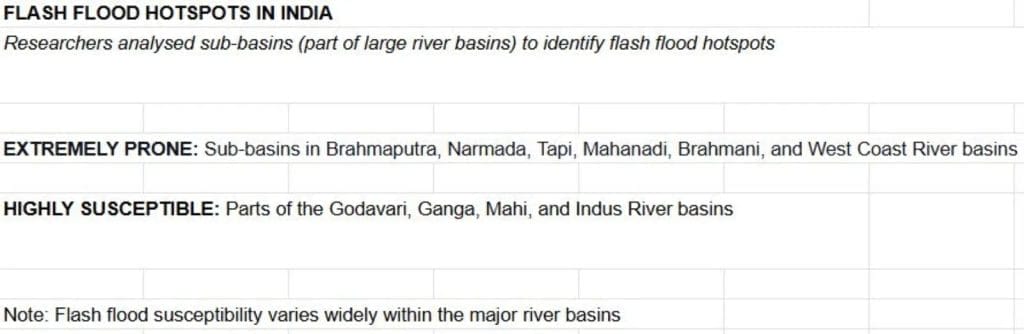
Flash floods occur most frequently in:
West Coast of India
Himalayas
Central India
Causes of Flash Floods:
Immediate Causes:
Only 25% of flash floods occur due to extreme rainfall within six hours.
Terrain-Related Causes:
Steep slopes and high relief (like Himalayas)
Climate Change Link:
Every 1°C increase in temperature raises moisture in air by 7%, intensifying rainfall.
Between 1981 and 2020, frequency of extreme rainfalldoubled during pre-monsoon in India.
Rainfall increased in monsoon, post-monsoon, and winter by:
56%, 40%, and 12.5% respectively.
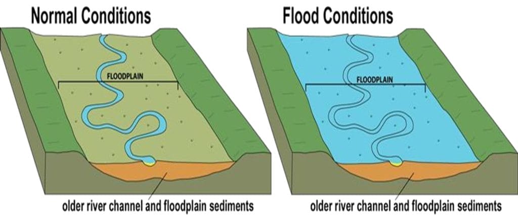
What is Flood:
According to National Weather service: An overflow of water onto normally dry land. The inundation of a normally dry area caused by rising water in an existing waterway, such as a river, stream, or drainage ditch. Ponding of water at or near the point where the rain fell. Flooding is a longer term event than flash flooding: it may last days or weeks.
What is Flash Floods:
According to National Weather service: A flood caused by heavy or excessive rainfall in a short period of time, generally less than 6 hours. Flash floods are usually characterized by raging torrents after heavy rains that rip through river beds, urban streets, or mountain canyons sweeping everything before them.
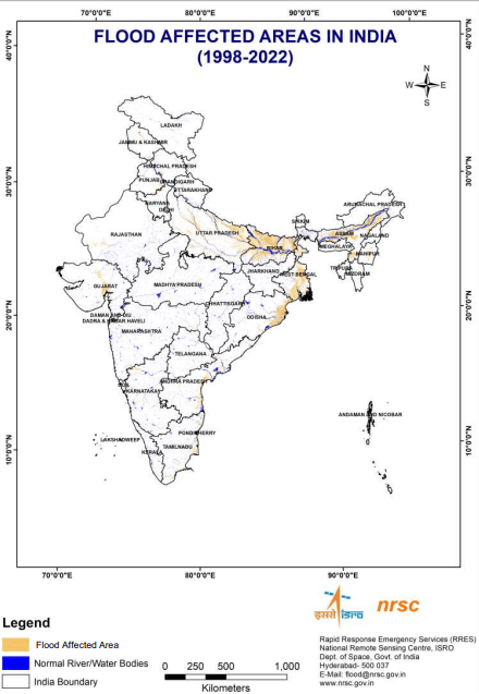
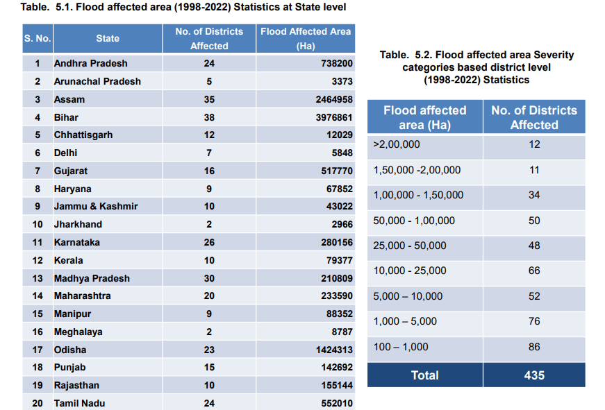
Flood prone areas in India:
Flood Atlas of India:
According to NDMA:
India is highly vulnerable to floods. Out of the total geographical area of 329 million hectares (mha), more than 40 mha is flood prone.
The average annual flood damage in the last 10 years period from 1996 to 2005 was Rs. 4745 crore as compared to Rs. 1805 crore, the corresponding average for the previous 53 years.
An average every year, 75 lakh hectares of land is affected, 1600 lives are lost and the damage caused to crops, houses and public utilities is Rs.1805 crores due to floods.
Causes:
More rain in less time.
Unplanned urbanisation.
Inadequate investment in drainage infrastructure.
Deforestation in catchment areas.
Extinction of natural water resources.
Silting of sewer lines.
Cloud Burst.
Cyclone.
Global Warming etc.
Himalayas, geomorphological factors — such as steep slopes, and high relief (when a landscape has a significant difference between a high point and a low point) — contribute to flash floods.
Impact:
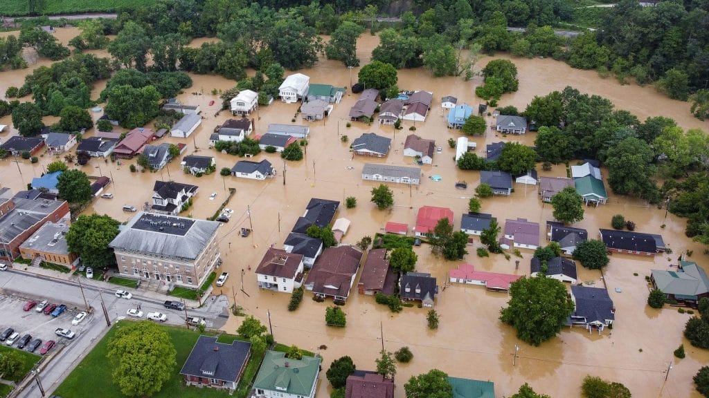
Human Loss and Property Loss: Every year, millions of people become homeless and washed away due to floods like Uttarakhand flood incident2013more than 5700 people died.
Spread of Communicable Diseases: Waterborne diseases like cholera, typhoid fever, hepatitis, and leptospirosis spread in flood-affected areas. Floods also lead to vector-borne diseases, transmitted through parasites and pathogens such as a mosquito. As a result, the health of flood victims deteriorates.
Destruction of Crops: Every year, floods destroy a large number of crops.
Loss of Livestock: Like humans, livestock also get displaced during floods and die due to the loss of their habitats.
Economic and Social Disruption: The economy comes to a standstill as people are forced to move to another place, and revival of this situation takes time.
Heavy traffic due to water logging.
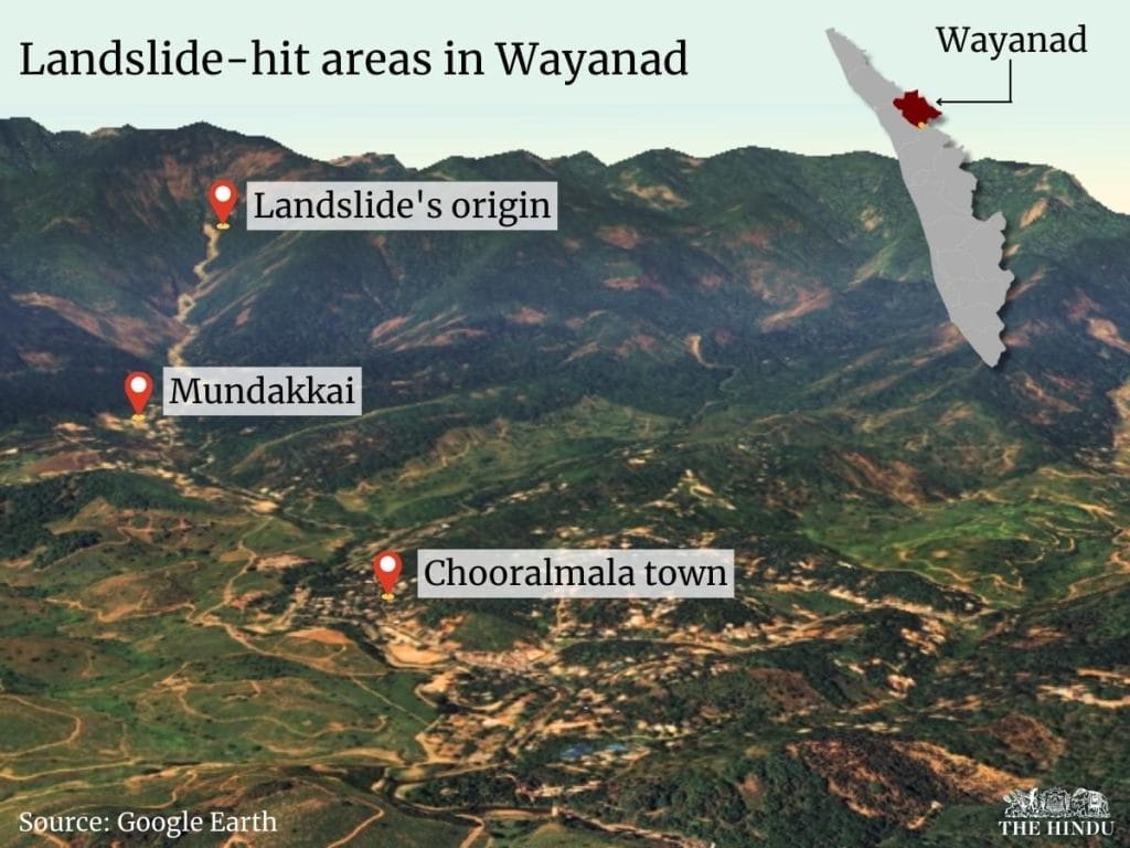
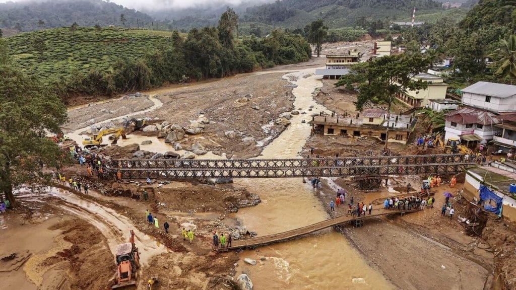
Landslides- like in Wayanad Kerala
Case studies:
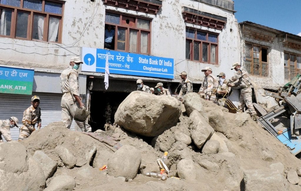
Ladakh:
In 2010, there were flash floods due to cloud burst in Leh in Ladakh region of North India. It rained 14 inches in 2 hours, causing loss of human life and destruction. The civil hospital of Leh was badly damaged and rendered dysfunctional. 234 persons died and over 800 were reported missing. Almost half of the people who died were local residents (49.6%) and foreigners (10.2%).
Wayanad Flood:
On July 30, 2024, devastating landslides struck the villages of Mundakki, Chooralmala, and Vellarimala in Wayanad District, Kerala, after days of heavy rainfall. The landslides caused severe damage, claiming lives, destroying homes, and affecting infrastructure. According to the State Emergency Operational Centre (SEOC) Kerala, 231 bodies and 212 body parts were recovered. In total, 630 people were injured, 214 rescued, and 119 remain missing.
Chennai:
The Chennai metropolitan region (CMA), with an area of 1,189 sq kms and a population of 8,653,521, is the fourth-largest populated city in India. This city, located in north eastern part of Tamil Nadu is a flat plain bounded on the east by Bay of Bengal and on the remaining three sides by Chengalpattu and Thiruvallur districts. Expansion in terms of area as well as population has led to a shift in land use and land cover patterns across the region. Chennai is exposed to violent storm surges and flooding during northeast monsoons (September to November). In November-December 2015, when a devastating flood affected more than 4 million people, claimed more than 470 lives and resulted in enormous economic loss.
Major NDMA Guidelines:
Maximizing the national hydro-meteorological network
Use of Doppler weather radar – weather forecasting and warning
Design of road and rail bridges – development of under-drainage systems
Every building in the urban area should have rain water harvesting as an integral part of the building utility.
Pre-monsoon desilting of all major drains is to be completed by 31st March every year.
GOI Steps:
River Linking Project
Amrit Sarovar Mission-Development and rejuvenation/rejuvenation of 75 water bodies in each district of the country.
Wetland Conservation
Best practice model in world to resolve flood Issue:
China Sponge City:
Sponge City is an urban construction model capable of tackling weather conditions such as monsoons, swelling, flooding or other water events, through drainage systems or areas that prevent the accumulation of water.
China has one of the highest numbers of sponge cities, with the objective of having 80% of its urban areas absorbing 70% of water by 2030. As the country deals with extreme weather conditions, it has long sought to make its highly populated cities less vulnerable to flooding and drought. A Sponge City integrates natural and engineered systems to manage rainwater sustainably, mimicking the natural water cycle within the urban environment.
Shenzhen, a city in China, exemplifies this initiative. Shenzhen Talent Park features floodable greenways around a coastal lake, acting as a sink for canals diverting runoff from the ultra-dense Houhai neighbourhood.
Wuhan
Wuhan is one of the pioneering cities in China to implement the sponge city initiative. The Wuhan Sponge City Programme aims to reduce waterlogging and improve water quality through the ecological remediation of existing urban water systems and the development of blue and green infrastructure to collect and store rainwater.
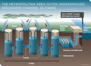
Japan Model:
Japan’s flood control system is a comprehensive approach combining structural and non-structural measures, with a strong emphasis on utilizing underground spaces to mitigate the impacts of heavy rainfall and typhoons. Key elements include large-scale underground reservoirs and tunnels, advanced monitoring and early warning systems, and a network of levees and floodgates.